
Research Area
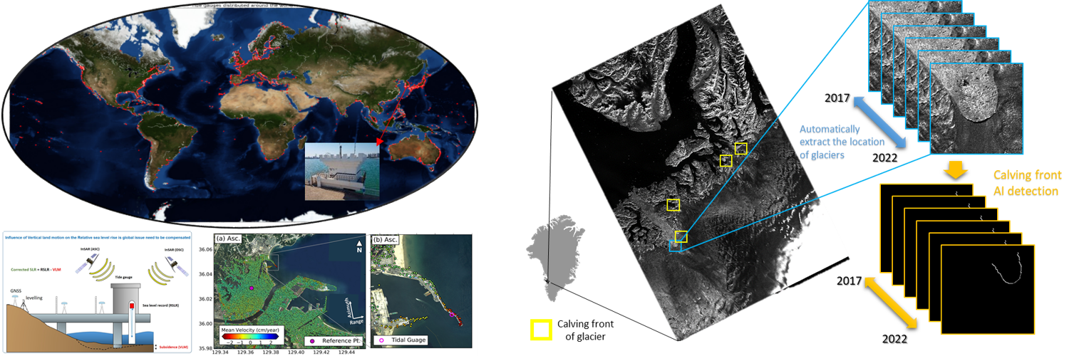
Environmental change has a significant impact on the littoral and polar regions. We focus on automatically, continuously and efficiently monitoring the specific changing factors including the fluctuations of sea level, distribution of sea ice, horizontal displacement of the calving front of glaciers, erosion and accumulation of tidal flat, using deep learning and InSAR technology based on high performance graphic cards and cloud-based processing, respectively. We attempt to solve the fundamental challenge in environmental monitoring by conducting advanced spaceborne-InSAR and deep learning research. Furthermore, the trends in large-scale environmental changes will be inferred, by establishing the relationship between these factors aided by the other environmental data, and it is possible to make accurate predictions about the future environmental changes of the specific region if additional local observation data is provided.
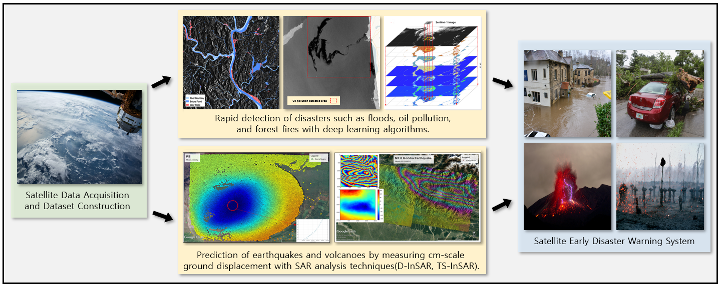
Day/night and all-weather capabilities of SAR facilitate continual disaster monitoring such as floods, oil spills, earthquakes, volcanic activities, and ground displacements. To detect floods and oil spills, deep learning is actively utilized for analyzing SAR data. Trained deep learning models can detect and specify the areas where rivers have overflowed or oil spills have occurred using the different scattering properties of water and oil. SAR can be utilized to estimate the movement of the Earth’s surface as well. Monitoring ground displacement is essential as it can be a precursor of earthquakes and volcanic eruptions. Differential Interferometric SAR (D-InSAR) and Time-Series Interferometric SAR (TS-InSAR) techniques have capability of measuring displacements at mm scale, which use multiple SAR images acquired from different positions (i.e., spatial baseline) and times (i.e., temporal baseline).
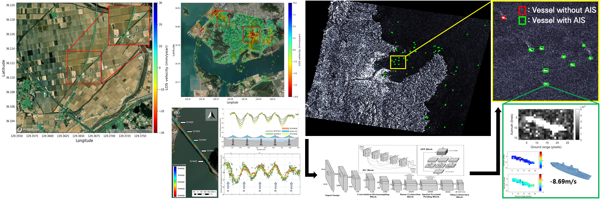
SAR remote sensing can be also utilized to ensure safety over man-made targets such as vessels or urban infrastructures. Vessels in the ocean of which the movement contains the danger of intruding the exclusive economic zone are able to be detected and monitored with CNN-based object detectors. Comparing the detected vessels against real-time information of the corresponding vessels also enables to evaluate their hazard and illegality, while exploiting SAR interferometry and Doppler frequency for deriving their velocity. Time-series accumulation of detected and unidentified vessels in particular regions of ocean and subsequently generated vessel density map provides an insight over coastal surveillance and management. In addition, displacement of civil infrastructures, and ground deformation caused by natural hazards is able to be quantified by InSAR. Extracting target movement from integrated phase difference, displacement rate of target for long period is also able to be calculated accurately. Monitoring for stability of infrastructure and quantification of spatially continuous ground deformation gives opportunities of emergency response system development.
Tel +82-2-880-6734 Fax +82-2-871-3269 E-mail djkim@snu.ac.kr
Location #420, Bldg. 25-1, School, Earth and Environmental Sciences, Seoul National University, 1 Gwanak-ro, Gwanak-gu, Seoul, 08826, Korea
Copyright 2018, SATGEO All Rights reserved.