
Research Area
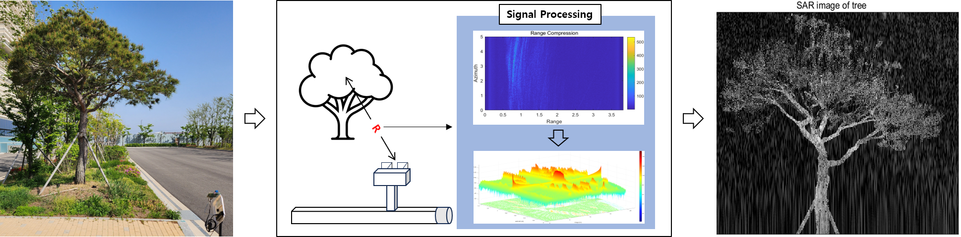
Signal Processing is technology for analyzing, modifying, and synthesizing the signal information. Since Synthetic Aperture Radar (SAR) data is generated by recording successive radar echoes from objects, radar signal processing is regarded as an imperative procedure in image restoration before its application. Our lab is researching the signal processing for the Reconstruction Algorithm of High - resolution SAR images and their utilization. We have developed a various band of SAR system and acquired the characteristics of an object by analyzing the chirp parameters and doppler frequency. SAR signal processing algorithms for various platforms, sensors and frequencies of radar have been researched. In order to validate the use of innovative approaches, SAR data is acquired in different platform conditions utilizing the Nano-SAR antenna or mmWave Radar.
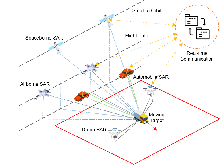
SAR data acquired from ground field experiments through airborne, automobile and drone are utilized in testing the prototypes for the next generation satellite SAR payloads and conducting useful missions intimately. Taking advantage of convenience, preliminary SAR experiments can be performed by creating similar environment to satellite geometry before loaded on it. For example, Cross-Track Interferometry (XTI) and Along-Track Interferometry (ATI) performed with airborne SAR and automobile SAR enables to extract 3D structure and velocity of moving targets such as vehicles in real time. Drone SAR explores the locations in potential danger where people cannot easily approach to.
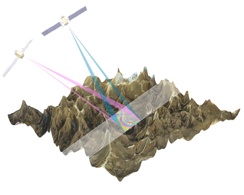
Interferometric SAR (InSAR) is a rapidly evolving remote sensing technique that exploits the phase differences of two or further complex-valued SAR imageries acquired from different sensor positions and at different times. We operate with space geodetic techniques for developing and validating time-series InSAR (PS-InSAR, SBAS, and comSAR) algorithms, advanced ionospheric phase delay rectification, and unwrapping error correction. Our lab researches to mitigate the APS (Atmospheric Phase Screens) delay effect by applying atmospheric properties which correspond to data acquisition time and improves the unwrapping algorithm for specific applications such as infrastructure monitoring, and large-scale ground motion. Currently, our lab aims to develop various delay effect correction algorithms to improve phase information in land motion and to mitigate wave refraction that causes geometrical positioning error of targets. Precise estimation of ground displacement from geophysical events is currently being developed utilizing improved selection of stable ground pixels and appropriate SAR image pairs. Our main challenge is to increase the precision of the measured InSAR displacement and further replenishment.
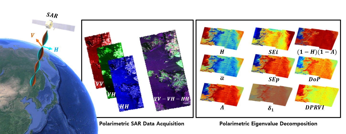
SAR polarimetry exploits the property of various pairs of perpendicular basis vectors, such as horizontal and vertical polarizations. With respect to the different target characters which induce the incidence to be polarized, SAR antenna captures the echo in a particular basis. Profound monitoring over the target’s physical character is able to be accomplished by implementing polarimetric decomposition. Natural or artificial changes which involve modification in scattering character are detectable utilizing polarimetric parameters; when accompanied by generation of novel polarimetric indexes which maximize the separation between the changed targets, monitoring precise deformation of interest targets is enabled. Diverse scattering mechanisms are also acknowledged in polarimetric indexes, which can be implemented to target recognition and classification. Our lab aims to open up new fields of application for multi-polarization satellites to be launched in the future.
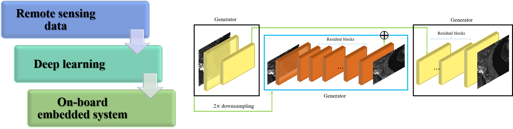
Among various artificial intelligence methods, deep learning is efficient technology at image analysis, including remotely sensed satellite images. Deep learning is one of machine learning techniques, which is based on neural networks. Common application of deep learning includes Convolutional Neural Network (CNN), an image-based deep learning algorithm which extracts the general pattern of targeted objects. Features of the natural environment and man-made objects can be efficiently monitored by such characteristics. The typical usage of deep learning includes image classification, segmentation, and object detection, and it is also employed to generate images by identifying the relationship between two different image datasets, e.g., Generative Adversarial Network (GAN). GAN can create various images, including super-resolution images. Super-resolution task is to convert low resolution images into high resolution images. Diverse studies, such as object detection and natural disaster analysis can be conducted through the super-resolution images generated by GAN. In addition to satellite data, our lab also researches new deep learning methods that fuse various types of data such as Geographic Information System (GIS), Global Navigation Satellite System (GNSS), and space-based data.
Tel +82-2-880-6734 Fax +82-2-871-3269 E-mail djkim@snu.ac.kr
Location #420, Bldg. 25-1, School, Earth and Environmental Sciences, Seoul National University, 1 Gwanak-ro, Gwanak-gu, Seoul, 08826, Korea
Copyright 2018, SATGEO All Rights reserved.